-
From
CGIAR Initiative on Asian Mega-Deltas
-
Published on
11.06.24
- Impact Area
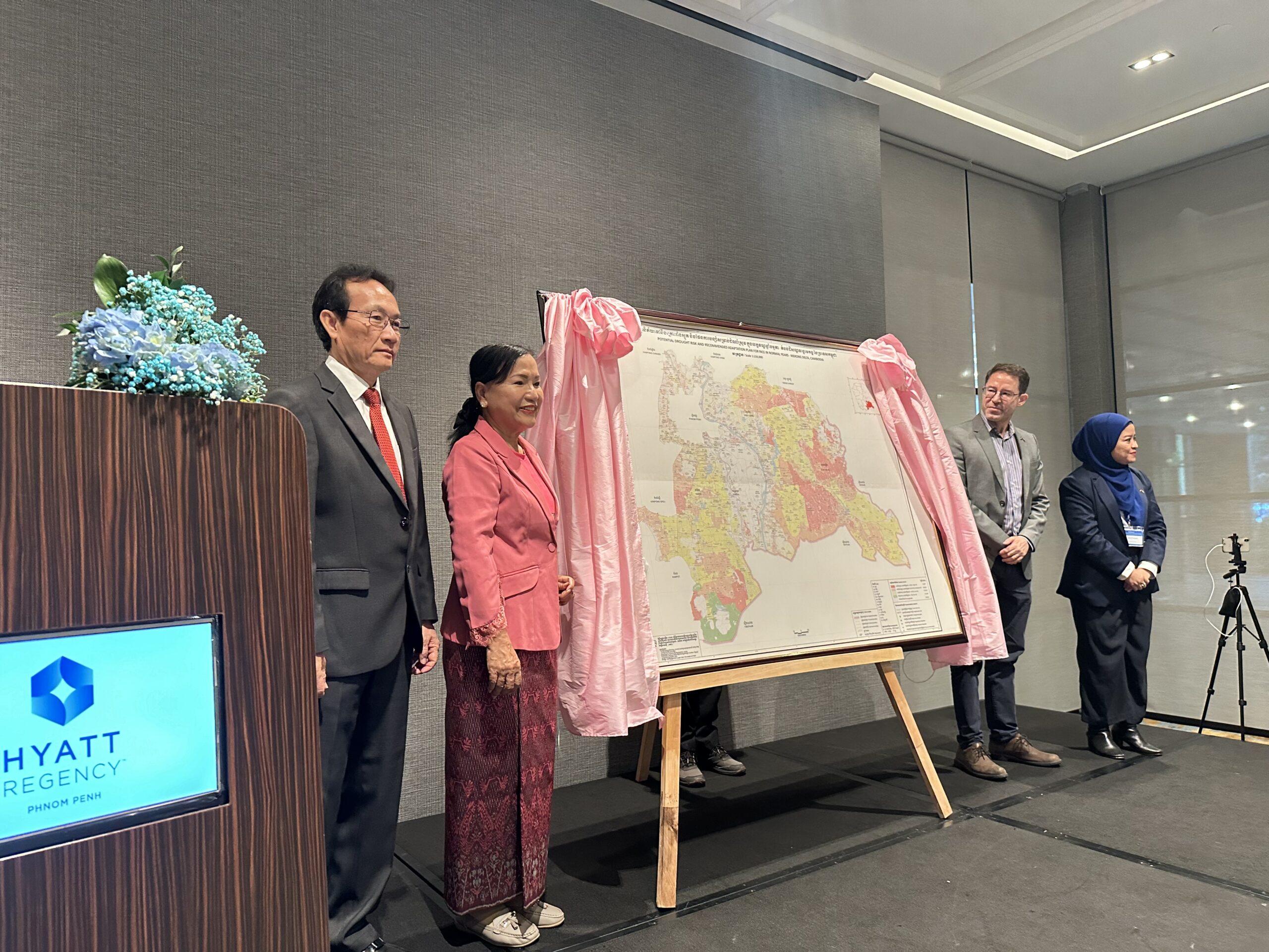
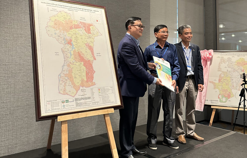
Phnom Penh, Cambodia (June 4, 2005) – The International Rice Research Institute (IRRI), and the national lead for climate-smart mapping, the General Directorate of Agriculture (GDA), launched the Atlas of Climate-Smart Maps and Adaptation Plans (CS-MAPs) for Cambodian Mekong Delta. The CS-MAP Atlas features risk maps and adaptation plans to address drought and flooding impacts for rice, corn, cassava, and vegetables.
The launch was led by H.E. Chan Phaloeun, Secretary of State of the Ministry of Agriculture, Forestry and Fisheries (MAFF) and Lead of the Technical Working Group for Climate. The event was also attended by Provincial Departments of Agriculture, Forestry and Fisheries (PDAFF) of the delta provinces, as well as government, civil sector, and university partners.

Since 2023, the CGIAR Initiative on Asian Mega-Deltas (AMD) has developed CS-MAPs for the Cambodian Mekong delta, specifically for Kandal, Takeo, Prey Vieng, and Svay Rieng provinces. The CS-MAPs are based on participatory mapping approach that integrates local knowledge with geographic information data. They enable visualization of the climate-related risks and provide location-specific adaptation plans for crop production that supports decision-making and planning.
In his opening remarks, Dr. Bjoern Ole Sander, the lead of AMD and Senior Scientist for Climate Change in IRRI, explained the importance of the approach, “AMD is addressing the most critical agro-ecosystems in the world, and they are experiencing climate change. Climate change is the biggest threat to rice, and it is no longer just a concept. We only can be prepared to face climate change and learn to adopt to it. In this case, our solution is CS-MAPs, which supports policy as a decision support tool”.
Both H.E. Dr. Ngin Chhay, Director General of GDA and H.E. Dr. Chan Phaloeun, indicated the importance of CS-MAPs in decision making and emphasized the importance of expanding the CS-MAPs to other provinces in Cambodia.

The participants brought up the importance of making the maps accessible to users other than policy makers, highlighting the significance of the CS-MAP approach. In their talk on the background, innovation description, and scaling ambition of the CS-MAPs, Dr. Seng Vang and Dr. Yen Tan Bui have explained the potential of incorporating CS-MAPs with other information such as weather, crop damage, pest, crop, land use and water to end up with crop insurance schemes, pest warning systems, short term crop management and crop suitability decisions, as well as land use planning.
In tandem, the event was also a workshop for assessing the scaling readiness of the CS-MAPs, to identify how this technology can reach the hands of target users. Dr. Rica Joy Flor, Innovation Systems Scientist in IRRI Cambodia, discussed with the participants the scaling ambition of the tool. The group agreed that “by 2027, the AMD initiative and partners will work together with MAFF to enable the use of CS-MAP tool by 4 provincial level decision makers, 20 district level decisionmakers, 4 farmer water users cooperatives, agricultural cooperatives or community fish refuges, benefitting 37,000 farming households in Cambodia contributing to increased climate resilience, as well as to livelihoods and food security”.
These challenges ranged from lack of awareness and affordability to concerns about user trust and technical know-how. However, the group also identified promising solutions for wider adoption. They proposed initiatives like training programs for farmers and agricultural officers, along with social media campaigns to raise awareness. By evaluating both the CS-MAP tool and these proposed solutions, the workshop aimed to identify key areas for strategic support, ultimately paving the way for successful scaling of CS-MAPs across Cambodia.
Related news
-

Mapping for Resilience: How Spatial Data is Transforming Karamoja Cluster
02.07.25-
Climate adaptation & mitigation
Pastoral communities in the Karamoja Cluster (a region spanning Kenya, Uganda, South Sudan, and Ethi…
Read more -
-

Building Resilience and Regeneration: The Central Highlands Ecoregion Foodscape (CHEF)
02.07.25-
Climate adaptation & mitigation
At the CGIAR Sustainable Farming Program (SFP), we believe that collaboration is essential for trans…
Read more -
-

Planting with Precision: How Weather and Climate Information is Changing Bean Farming in Rwanda
01.07.25-
Climate adaptation & mitigation
Imagine weather information as a GPS for farmers. Without it, the journey becomes uncertain, filled…
Read more -