-
From
CGIAR Initiative on Digital Innovation
-
Published on
29.09.23
- Impact Area
Researchers at the Alliance of Bioversity-CIAT and the University of Galway have developed a method to track agricultural adaptation to climate change from the global to the farm level using satellite remote sensing. The “Biomass Climate Adaptation Index” overcomes challenges that until now have prevented progress assessment of climate change goals and will enable more responsive investments and interventions to build climate-resilient food systems.
To learn more about this story and other methodologies, register for Adaptation Futures 2023 (2-6 October) and hear from Jawoo Koo, CGIAR Digital Innovation lead (session 524, 3 Oct 3PM UTC/GMT)
Under the current trajectory, climate change mitigation efforts alone will not prevent significant harm to farming livelihoods and food security. Agricultural systems must also adapt to phenomena such as higher temperatures, altered rainfall patterns or more frequent and intense extreme weather events. Unlike climate mitigation, which can be observed in greenhouse gas emission reductions, there are no commonly agreed-on metrics or methods to assess the effectiveness of climate adaptation in agriculture.
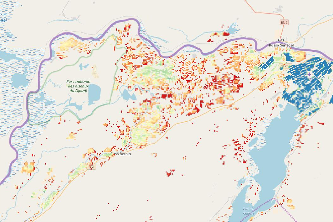
The paper, “Can remote sensing enable a Biomass Climate Adaptation Index (Biomass CAI) for agricultural systems”, published by Frontiers in Climate proposes a method based on Vegetation Indices (VIs). Plants absorb differently certain bands of light spectrum during photosynthesis. VIs exploit these differences in farmers’ fields to measure how much photosynthesis is taking place and assess the status of the vegetation. This provides a common indicator for agricultural performance that is low cost, available at different scales and comparable across agricultural systems.
To understand the impact of adaptations it is necessary to have a baseline for comparison. For this, the researchers propose using a synthetic counterfactual approach. To do so, computer models are trained over a baseline period to predict VIs in agricultural systems using data such as rainfall, temperature, and soil moisture. By comparing the output provided by the models with real-world satellite observations during climatic shocks, such as drought and floods, the system identifies deviations from the baseline trends and provides an index of how effective adaptation efforts have been.
The Biomass Climate Adaptation Index is made possible by technological innovations such as the wide availability of satellite images, and machine learning approaches to improve the resolution of images and provide the accurate predictions of VI needed for the index. Work on Biomass CAI partly took place under the CGIAR Research Initiative on Digital Innovation, which generates evidence for the potential of digital solutions to transform agricultural systems.
The work is significant for the dilemma of incremental versus transformational adaptation to climate change in agriculture. While simple changes such as adjusting planting times may help farmers adapt in the short- or medium-term, they may not be enough to ensure the ultimate survival of their agricultural system under climate change. In this case, it would be better to invest earlier in a transformational adaptation to a different agricultural system that can survive. However, transformational adaptations are riskier and more difficult to implement.
Biomass CAI is a source of evidence for when incremental adaptations are working, and when planning for a transformational change should begin. This can effectively remove the dilemma by integrating both choices as part of an “Adaptation Action Cycle.”
Climate change adaptation efforts in general could benefit from better planning, funding and stakeholder involvement. As Biomass CAI can be measured at different geographic scales, it can support planning and investment decisions by different actors at the global, national, regional or farm levels. According to the study authors, the method may be most powerful when used to inform “precision adaptations” at the farm level, across spaces at 10-60 square meters in area. Farmers could access Biomass CAI from their phones to find out which adaptations are performing best on their farms.
To realize this potential, the Tracking Adaptation Progress in Agricultural Systems (TAPAS) program is implementing Biomass CAI based on different sources of satellite imagery to provides analysis at different scale Further research and partnerships will be required for different stakeholders to adopt Biomass CAI, while the method itself could be applied to other areas such as conservation of marine systems or biodiversity.
Related news
-

Mapping for Resilience: How Spatial Data is Transforming Karamoja Cluster
02.07.25-
Climate adaptation & mitigation
Pastoral communities in the Karamoja Cluster (a region spanning Kenya, Uganda, South Sudan, and Ethi…
Read more -
-

Building Resilience and Regeneration: The Central Highlands Ecoregion Foodscape (CHEF)
02.07.25-
Climate adaptation & mitigation
At the CGIAR Sustainable Farming Program (SFP), we believe that collaboration is essential for trans…
Read more -
-

Planting with Precision: How Weather and Climate Information is Changing Bean Farming in Rwanda
01.07.25-
Climate adaptation & mitigation
Imagine weather information as a GPS for farmers. Without it, the journey becomes uncertain, filled…
Read more -